The ALTOS activities cover a three-year period and are structured into six interconnected work packages (Figure 3.1), including WP6 on management and communication. The methodological framework was elaborated by the consortium toward the best approach to address the impact of spatial structures and connectivities on matter fluxes and storages. Below are summary descriptions of the work packages.
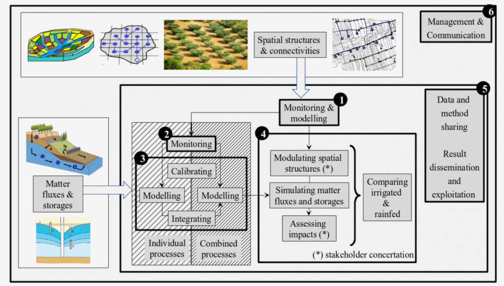
Deals with innovative monitoring and modelling tools for characterizing spatial structures. It includes the use of innovative sensors with high spatial resolution and of innovative methodologies for data processing.
- Task 1.1 : object geometries and landscape structure [leader: IRTA].
- Task 1.2 : landscape featuring [leader: LISAH].
Addresses innovative monitoring tools for characterizing matter fluxes and storage driven by spatial structures. It includes innovative experimental protocols that rely on the joint use of complementary measurements.
- Task 2.1 : water and chemical fluxes [leader: CERTE].
- Task 2.2 : spatial heterogeneities [leader: CESBIO].
Uses outcomes from WP1 and WP2 to address innovative modelling for simulating individual (e.g., evapotranspiration) and combined processes (e.g., combined hydrological cycle and crop functioning). It includes calibration procedures that rely on distributed and nested measurements to simultaneously calibrate several model parameters.
- Task 3.1: modelling individual processes [leader: UNICA].
- Task 3.2: modelling combined processes [leader: INAT].
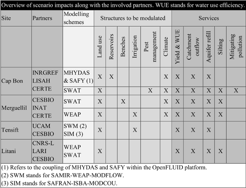
Combines outcomes from WP1 and WP3 to simulate matter fluxes and storages for possible structure modulations. Obtained simulations are translated into indicators for integrated analysis with stakeholders during participative seminars (see table below). WP4 also includes a cross-analysis for irrigated and rainfed agrosystems, by comparing vulnerabilities and adaptabilities on the basis of indicators related to water availability and agricultural yield.
- Task 4.1: setting up scenarios [leader: UCAM].
- Task 4.2: impact assessment and scenario ranking [leader: INRGREF].
- Task 4.3: comparing irrigated and rainfed agrosystems (leader: LISAH).
Conducts pooling of data and methodologies between project partners and throughout project duration, by using several means such as dedicated platforms, workshops, mobilities. WP5 is also in charge of the dissemination and exploitation of the project results according to the type of outcome and target audiences (see Table 2.2 in Section 2)
- Task 5.1: sharing of data and methods [leader: all partners]
- Task 5.2: dissemination and exploitation of project results [leader: INRGREF].
- Task 6.1: Coordination and Management [Leader: LISAH].
- Task 6.2: Communication [Leader: LISAH].